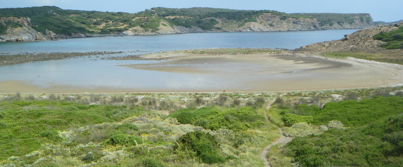
ES533MEN143 - Ses Mamaes Primes
Description

Wetland data
Basic information
| Wetland location: | Marine/Coastal |
| Wetland type: | Natural |
| Wetland area: | 2.3 Ha |
| Hydrological interaction: | - |
| Water salinity: | Salty (> 18.0 g/l) |
| Type of fresh water input: | Catchment area (precipitation) |
| Surface water runoff | Outflow from lakeshore or river |
| Open water area (%): | > 95 |
| Hydroperiod: | Permanent |
Geographic information
| Region: | Balearic Islands |
| Island: | Menorca |
| Municipality: | Maó |
| Longitude: | 4.258673 East |
| Latitude: | 39.963527 North |
Wetland condition
| Wetland status (MEDWET): | 1 - Untouched. No signs of man-made changes |
Ramsar wetland type
| Type | Coverage (%) |
| A — Permanent shallow marine waters | 51 - 75 |
| E — Sand, shingle or pebble shores | 26 - 50 |
Property status
| Maritime-Terrestrial Public Domain |
| Protection status category | Protection status subcategory | Area's name | Code | Coverage area (%) | Legislation |
| Regional protection | Natural Park | Albufera des Grau | 100 | ||
| Other international protection | Biosphere Reserve | Menorca | 100 | ||
| Other international protection | Natura 2000 | S’Albufera des Grau (LIC, ZEPA) | ES0000234 | 100 | |
| Other | Urban planning regulations | S'Albufera des Grau | ANEI-Me 7 | 100 | Ley 1/1991 |
Important bird areas
| IBA code | Site name | Coverage (%) | References |
| ES325 | North and East Coast of Menorca and Aire Island | 100 | Infante et al., 2011 |
Ecosystem services
| Type of ecosystem service | Ecosystem service | Scale of Βenefit (%) | Importance |
| Regulatory services | Erosion regulation | ||
| Supporting services | Nutrient cycling | ||
| Supporting services | Provision of habitat | ||
| Regulatory services | Storm hazard regulation |
Activities on wetland
| Activity | Intensity |
Activities on catchment area
| Activity | Intensity |
| 501 = paths tracks cycling tracks | High |
| 622 = walking horseriding and non-motorised vehicles | High |
Habitat types
| Type | Coverage (%) |
| 1410 Mediterranean salt meadows (Juncetalia maritimi) | < 5 |
| 1210 Annual vegetation of drift lines | 5 - 25 |
| 2120 Shifting dunes along the shoreline with Ammophila arenaria (‘white dunes’) | 5 - 25 |
| 2210 - Crucianellion maritimae fixed beach dunes | 5 - 25 |
Flora
| Species | Presence status | References |
| Ammophila arenaria (Linnaeus) Link 1827 | Present | |
| Eryngium maritimum Linnaeus 1753 | Present | |
| Juncus acutus Linnaeus 1753 | Present | |
| Pancratium maritimum Linnaeus 1753 | Present |
Fauna
Birds |
Number of individuals |
Nesting |
References |
| Charadrius alexandrinus Linnaeus 1758 | 1-10 | Nesting | Méndez, 2010 |
| Charadrius dubius Scopoli 1786 | 1-10 | Nesting | Méndez, 2010 |
| Phalacrocorax aristotelis (Linnaeus 1761) | 1-10 | Not nesting |
Infante, O., Fuente, U. & Atienza, J.C. 2011. Las Áreas Importantes para la Conservación delas Aves en España. SEO/BirdLife. Madrid.
Méndez, J. 2010. Atles dels Ocells Nidificants al Parc Natural de s’Albufera des Grau. Informe inèdit per Espais de Natura Balear. Conselleria de Medi Ambient del Govern de les Illes Balears.
Sitibsa, 2006b. Document tècnic de delimitació, caracterització, classificació i inventari de les zones humides de les Illes Balears. Cartografia Vegetal de les Zones Humides de les Illes Balears. Conselleria de Medi Ambient. Govern de les Illes Balears.
Images