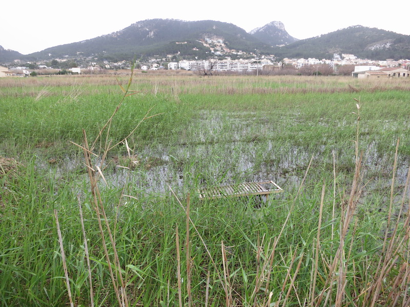
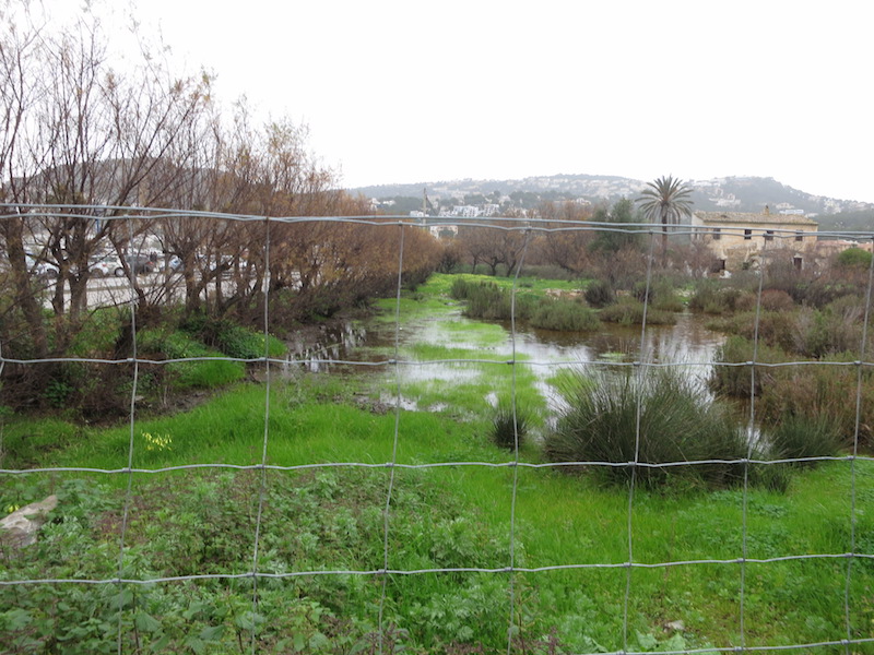
ES532MAL018 - Port d'Andratx marsh
Description
Wetland data
Basic information
| Wetland location: | Marine/Coastal |
| Wetland type: | Natural |
| Wetland area: | 18.5 Ha |
| Hydrological interaction: | - |
| Water salinity: | Brackish (5.0-18.0 g/l) |
| Type of fresh water input: | Catchment area (precipitation) |
| Surface water runoff | Outflow from lakeshore or river |
| Open water area (%): | 26 - 50 |
| Hydroperiod: | Seasonal |
Geographic information
| Region: | Balearic Islands |
| Island: | Mallorca |
| Municipality: | Andratx |
| Longitude: | 2.391597 East |
| Latitude: | 39.548511 North |
Wetland condition
| Wetland status (MEDWET): | 4 - Original habitats/landform highly modified (<10% untouched) |
Ramsar wetland type
| Type | Coverage (%) |
| H — Intertidal marshes | > 95 |
Property status
| Públic/Private |
| Protection status category | Protection status subcategory | Area's name | Code | Coverage area (%) | Legislation |
| Other international protection | UNESCO World Heritage Site | Cultural Heritage of the Serra de Tramuntana | 1371 | 100 | |
| Other | Urban planning regulations | Es Saulet | ANEI Ma-31 | 100 | Ley 1/1991 |
Ecosystem services
| Type of ecosystem service | Ecosystem service | Scale of Βenefit (%) | Importance |
| Regulatory services | Flood hazard regulation | ||
| Provisioning services | Food | ||
| Supporting services | Nutrient cycling | ||
| Supporting services | Provision of habitat | ||
| Regulatory services | Water purification | ||
| Regulatory services | Water regulation |
Activities on wetland
| Activity | Intensity |
| 040 = Land restoration | Medium |
| 100 = Cultivation | High |
| 403 = dispersed habitation | High |
| 501 = paths tracks cycling tracks | Medium |
| 502 = roads motorways | High |
| 511 = electricity lines | High |
| 622 = walking horseriding and non-motorised vehicles | Medium |
| 701 = water pollution | Unknown |
| 703 = soil pollution | High |
| 830 = Canalisation | High |
| 870 = Dykes embankments artificial beaches general | High |
| 941 = inundation | High |
Activities on catchment area
| Activity | Intensity |
| 100 = Cultivation | High |
| 403 = dispersed habitation | High |
| 423 = disposal of inert materials | Medium |
| 440 = Storage of materials | Low |
| 502 = roads motorways | High |
| 504 = port areas | High |
| 590 = Other forms of transportation and communication | High |
| 620 = Outdoor sports and leisure activities | High |
| 701 = water pollution | Unknown |
| 703 = soil pollution | High |
| 830 = Canalisation | High |
| 910 = Silting up | High |
| 941 = inundation | High |
Impacts
| Impact | Intensity |
| AS- = Loss of scenic value | Medium |
| EW- = Increase in wilderness/wildlife values | High |
| HL- = Habitat loss | High |
| LP- = Decrease in prevention of salt intrusion | Medium |
| LR- = Decrease in flow regulation | High |
| LU- = Decrease in tourist/recreation potential | High |
| LW- = Decrease in wilderness/wildlife values | Medium |
| PFO = Fertiliz./Excess nutrient pollut. of an unknown severity/duration | Unknown |
| SS- = Soil siltation | High |
| WF- = Increase in flooding | High |
| WGT = Lowering of water table | High |
| WS- = Salt water intrusion | High |
Habitat types
| Type | Coverage (%) |
| 1410 Mediterranean salt meadows (Juncetalia maritimi) | < 5 |
| 92D0 Southern riparian galleries and thickets (Nerio-Tamaricetea and Securinegion tinctoriae) | < 5 |
| 1420 Mediterranean and thermo-Atlantic halophilous scrubs (Sarcocornetea fruticosi) | < 5 |
Flora
| Species | Presence status | References |
| Juncus acutus Linnaeus 1753 | ||
| Phragmites australis (Cavanilles) von Trinius ex v | Dominant | |
| Sarcocornia fruticosa (Linnaeus) Scott | ||
| Tamarix sp. |
Fauna
Birds |
Number of individuals |
Nesting |
References |
| Anas platyrhynchos Linnaeus 1758 | 10-100 | Nesting | Manchado et al., 2017 |
| Actitis hypoleucos (Linnaeus 1758) | 1-10 | Not nesting | Manchado et al., 2017 |
| Ichthyaetus audouinii (Payraudeau 1826) | 1-10 | Not nesting | Manchado et al., 2017 |
| Larus michahellis Naumann 1840 | 10-100 | Not nesting | Manchado et al., 2017 |
| Gallinula chloropus (Linnaeus 1758) | 1-10 | Nesting | Manchado et al., 2017 |
| Acrocephalus scirpaceus (Hermann 1804) | 10-100 | Nesting | |
| Ardea cinerea Linnaeus 1758 | 1-10 | Not nesting | Manchado et al., 2017 |
| Egretta garzetta (Linnaeus 1766) | 1-10 | Not nesting | Manchado et al., 2017 |
| Phalacrocorax carbo (Linnaeus 1758) | 1-10 | Not nesting | Manchado et al., 2017 |
Amphibians |
Presence status in wetland |
References |
|
| Pelophylax perezi (Seoane, 1885) | Present | Bioatles-CAIB, 2017 | |
Fishes |
Presence status in wetland |
References |
|
| Anguilla anguilla (Linnaeus, 1758) |
Bioatles-CAIB, 2017. http://bioatles.caib.es/serproesfront/VisorServlet
GRAM. 2010. Pla de Gestió del Prat de Saluet (Port d'Andratx). Pla de recuperació del Sistema de drenatge històric de la zona humida. Informe inèdit per l'Ajuntament d'Andratx. 25 pàgs.
Manchado, J., Méndez, X, Suárez, M. & Cardona, E. Recompte hivernal d'aus aquàtiques, limícoles i gavines a les Balears, gener 2017. AOB 2016, vol 31: 25-38. GOB. Palma.
Images